Contents
Introduction
Paragliding weather on the Dune du Pilat (you'll find dune du Pyla spelled out too) is a key factor for your next flight because it guarantees :
- a better in-flight experience
- safety
On our " weather on Dune du Pilat " :
- all current weather forecasts for Dune du Pilat
- short-term weather forecasts (what the weather will be like on the dune in the coming days)
- a record of wind strength and direction
To find ideal weather conditions for flying on the Dune du Pilat spots you need :
- North-northwest to west winds
- Wind speeds of 15 to 28 km/h (depending on direction)
But if you see our weather page Dune du Pilat paragliding weather forecast in real time if the wind is over 25 km/h with gusts to 50 km/h, don't worry, you can still fly in complete safety by adapting the size of your glider (i.e. taking a smaller one).
It's not just the direction and strength of the wind that define an optimal flight, other factors also come into play and vary according to the time of year and the time of day.
You also need to master :
- its placement in relation to the terrain (Venturi effect, turbulence, retreat from the other side of the dune)
- sea breeze (formation, seasonal influences)
- dynamic ascents
- thermal updrafts
- the angle of the wind on the terrain
- the weather wind
- etc.
All these factors are taken into account by our paragliding instructors to help you offer a safe flight.
The proof?
Not a single accident at Dune Parapente!
If you're looking for best time to fly a tandem paraglider (tandem) on the Dune du Pilat during your stay in the Arcachon Basin, then contact me :
➟ I'll help you find the perfect day and time.
If you're passionate about aerology and want more advanced weather information and paragliding conditions, I suggest you discover the weather on Dune du Pilat in our paragliding guide.
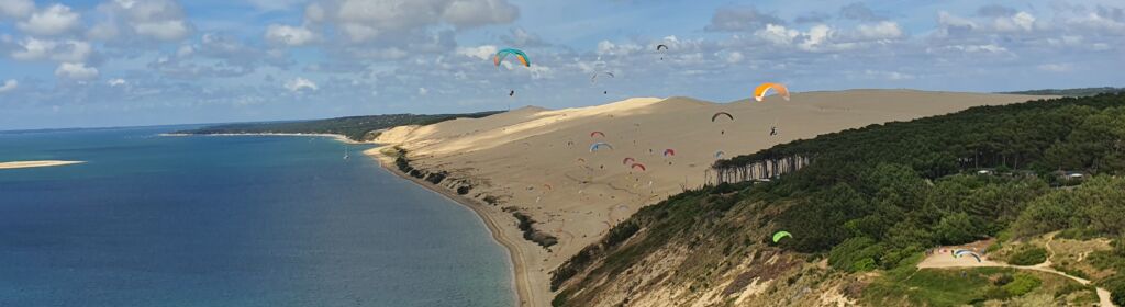
To fly at the Dune du Pilat, which is a site with a small vertical drop of less than 100m, it's important that the wind is well oriented and that a dynamic lift is in place to make the flights last.
This spot is one of the most popular for paragliding thanks to its unique conditions.
Wind and lift conditions
Wind and ideal orientation
A dynamic ascendancy is created when the wind is sufficiently perpendicular to the relief and sufficiently strong.
On the site of the Grande Dune du Pilat, ideal orientation is northwestBut we fly well when the wind is also from north to west-south-west, i.e. in degrees from 247° to 0°.
As far as wind strength is concerned, it is necessary to if the wind is perpendicular the relief (between north and west-northwest), the minimum average speed of about 15km/h.
Warning: If the wind is more crosswind (west-southwest), it should average 20km/h.
We manage to fly with wind gusts of around 50km/h, on this type of seaside site.
The waves of the Atlantic Ocean, visible from the dune, add a spectacular view to the flight.
Dynamic and thermal ascents
When we fly on this site, we do what is known as slope flying, also called soaring and it's the dynamic lift that allows us to evolve along the dune and make Waggas.
Thermal updrafts (bubbles of warm air that allow you to gain altitude) also occur occasionally, but they are often ephemeral and sporadic on this site, and are complementary.
Videos of these flights often show impressive maneuvers.
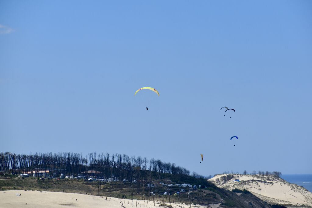
Types of sails used
At Dune Parapente, we have 2 types of canopy, classic-sized canopies, which enable us to fly at gusts of up to 40 km/hr.
As soon as the wind exceeds 30 km/h on average and 40 km/h in gusts, we use smaller sails, sometimes called mini-sails.
These mini-sails have maximum speeds of between 60 and 65km/h, allowing us to remain manoeuvrable with a safety margin when wind gusts reach around 50 km/h.
Precautions for experienced pilots
Beware, this type of practice is reserved for very experienced pilots.
When I say that we can fly in gusts of up to around 50km/h, I mean that in a very real sense. reserved for highly experienced pilots and adapted equipment.
What's more, it depends on whether the air mass is turbulent or not; the greater the difference between the average and the gusts, the more turbulent the air mass.
Weather forecast
Forecasting models
For a good weather forecast, it's important to use a model.
The most accurate and reliable model in France is the Arome HD 1.3 model
But unfortunately, this model does not forecast beyond 48 hours.
That's why we always wait until the evening before to give you the most reliable forecast.
After that, other weather models like Arpège or GFS give a trend over several days.
Some weather sites, such as Météoblue give multi-models with one-week trends, averaged over several models.
We have a weather page which takes you to weather links, including the weather beacon that gives you the wind in real time on the site, because going to Windy or finding available webcams in La Teste and Cap Ferret for a live view isn't enough.
Wind sources
The wind that creates the dynamic lift on the Dune du Pilat can have two origins:
Weather wind
The first is the meteorological wind, which is linked to a pressure gradient between anticyclones and depressions.
Remember Evelyne's card at the beginning of the weather forecast.
High-pressure zones (anticyclone, greater than 1013 hpa - units of pressure - at the sea surface) compress the air towards the ground, clockwise in the Northern Hemisphere (Coriolis force, the opposite in the Southern Hemisphere), from the center (where the pressure is greatest) of the anticyclone outwards.
Low-pressure areas (low pressure, below 1013 hpa) pull the air upwards in an anti-clockwise direction, moving from the outside of the low towards the center (from the highest pressures towards the lowest).
The tighter the isobars, the stronger the wind (pressure gradient over a small area).
The wind direction is perpendicular to the isobars.
Sea breeze
The second origin is the sea breeze, linked to a thermal characteristic: when the earth heats up with the sun, the air in contact with the ground is heated and rises.
But this void needs to be filled, and the cooler air over the sea replaces it.
A flow is established between the sea and the land behind the coastline, sometimes over dozens of kilometers.
This usually happens in the early afternoon, when the sun has warmed sufficiently.
The cooler the background air (temperature differential), the earlier this occurs, especially in spring, and the greater the intensity of the breeze.
In summer, however, this often happens later in the day.
Generally speaking, its orientation changes during the day from west-northwest to north, intensifying as the day progresses, then fading either gradually or very quickly.
Often, when it sets in, it lifts the air mass and creates thermal ascents or bubbles, which are well exploited because they are not too flat and disorganized by the wind, as the breeze is not yet strong, which sometimes allows us to climb higher in the first few hours of breeze.
In the evening, we can get some "restit" (restitution: an aerological fact linked to the heat stored in particular by the forests, during a fine sunny day, and which is restituted at the end of the day; this creates a broad and gentle thermal lift in general), which sometimes also enables us to climb higher.
When summer conditions are scorching, it's rare for the breeze to set up correctly in terms of duration and intensity.
And as the wind is often weak or non-existent during heatwaves, we can't fly on the Dune du Pilat site.
Favorable seasons and periods
Spring and summer
To sum up, when a low-pressure system arrives on the coast in spring and summer, the wind is often westerly-south-westerly, and when it passes, the wind gradually shifts from westerly to north-westerly.
We often have very fine conditions at this time, despite the occasional risk of showers (depressions are often less humid at this time of year).
What's more, rain doesn't usually last long on the coast and often falls further inland.
At these times of year, sea breezes are easy to set up.
The best time to paraglide is from early April to late September.
Our statistics show that this period offers best conditions for this activity.
Autumn and winter
Unfortunately, in late autumn and winter, passing lows shift the wind more to the southwest, bringing more rain and stronger winds.
What's more, during these wintry periods, sea breezes don't kick in because the sun doesn't heat up enough, and the sea is often at the same temperature or even warmer than the land.
That's why weather conditions at these times are so important. not conducive to paragliding on the Dune du Pilat.
Additional aerological factors
Air density
In terms of aerology, other factors come into play, including air densityThe colder it is and the denser the air, the less wind intensity is needed to maintain lift.
On the other hand, in the mountains, for example, the higher you go, the lower the air density and the more wind you need to achieve the same dynamic lift.
Wind layer thickness
What's more, wind layer thickness against the relief will come into play.
This is because the force of the wind is sometimes not the same down on the beach as up on the dune, in addition to the acceleration effect of the slope.
The stronger the wind at the bottom, the better the efficiency of the lift.
The wind layer can also be compressed by low cloud cover, which also increases the intensity and improves the efficiency of dynamic lift.
Height and verticality of the relief
The height of the relief and its verticality will come into play: the steeper the relief (like a cliff) and the higher the relief, the better the efficiency of the lift will be, and the less wind you'll need.
Meteorological influence of clouds and squalls
Clouds are important too.
The lower they are, the greater the pressure gradient between ground and cloud base, and the greater the wind force.
Visit grains (brief rainy spells) can accentuate wind strength (known as squall lines).
However, once they've passed, wind strength can drop sharply.
Tide and sunshine
For the sea breeze, the tide can also be important, the stall (time between two tides) sometimes cutting off the phenomenon.
What's more, if the sky is full of clouds and hides the sun, the breeze can stop and start up again as soon as the sun reappears.
To keep track of these conditions, it's a good idea to subscribe to weather alerts.
Security and investment
It's important to remember that the stronger the wind, the greater the turbulence associated with the different landforms - it's exponential, for example, in strong winds, waves become reliefs which disrupt the air flow and create turbulence.
When the wind is strong, to fly safely, think about your position in relation to the terrain (beware of Venturi effects, compression points, turbulence zones linked to relief, etc.).
Also take safety margins in terms of wind strength.
On the seaside, the air mass is not as disturbed as in the mountains by the various reliefs that create turbulence.
To understand these different types of fluid mechanics, we can compare air with water and observe a river, for example; this can sometimes be more useful in understanding aerology.
In brief
The Dune du Pilat is an exceptional spot for paragliding, offering unique and varied conditions.
To maximize the safety and enjoyment of this activity, it is crucial to understand and carefully monitor weather and air conditions.
Tandem pilots are lucky enough not to have to worry about any of this, as their paragliding instructor takes care of the "good flight on the Dune du Pilat" / "local weather conditions" match.